![](/images/other/stat-length.png)
![Randonnée A pied Kirchheim am Neckar - Kirchheimer Wanderweg - Photo](https://media.geolcdn.com/t/1900/400/35ba73c6-5a71-4f63-bf37-f4aa5f37458e.jpeg&format=pjpeg&maxdim=2)
Kirchheimer Wanderweg
SityTrail - itinéraires balisés pédestres
Tous les sentiers balisés d’Europe GUIDE+
![Longueur](/images/other/stat-length.png)
Longueur
9,8 km
![Altitude max](https://static1.geolcdn.com/siteimages/upload/files/1508320355ic_sort_altitude_max_24dp.png)
Altitude max
237 m
![Dénivelé positif](https://static1.geolcdn.com/siteimages/upload/files/1508320355ic_sort_den_pos_24dp.png)
Dénivelé positif
130 m
![Km-Effort](/images/other/stat-length.png)
Km-Effort
11,6 km
![Altitude min](https://static1.geolcdn.com/siteimages/upload/files/1508320355ic_sort_altitude_min_24dp.png)
Altitude min
167 m
![Dénivelé négatif](https://static1.geolcdn.com/siteimages/upload/files/1508320355ic_sort_den_neg_24dp.png)
Dénivelé négatif
130 m
![Boucle](https://static1.geolcdn.com/siteimages/upload/files/16400158638029165_repeat_loop_refresh_sync_direction_icon.png)
Boucle
Oui
Balise
Date de création :
2022-02-11 15:58:57.073
Dernière modification :
2022-02-11 15:58:57.073
![A pied](https://static1.geolcdn.com/sitytour/trail-icons/100.png)
2h37
Difficulté : Facile
![Scannez ce code QR pour ouvrir la randonnée dans l'application SityTrail](https://capi.geolives.com/qq0zvz2zws4bq2lad0pu/sitytour/trails/3095557/qr.png?size=200)
Application GPS de randonnée GRATUITE
À propos
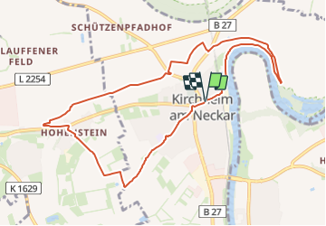
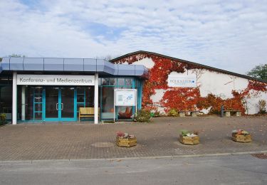
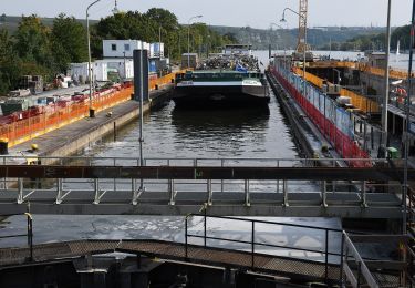
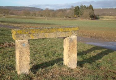
Randonnée A pied de 9,8 km à découvrir à Bade-Wurtemberg, Landkreis Ludwigsburg, Kirchheim am Neckar. Cette randonnée est proposée par SityTrail - itinéraires balisés pédestres.
Description
Randonnée créée par Schwäbischer Albverein e.V., Ortsgruppe Kirchheim.
Symbole: Kirchheimer Wappen: Weiße Kirche im blauen Schild
Localisation
Pays :
Allemagne
Région :
Bade-Wurtemberg
Département/Province :
Landkreis Ludwigsburg
Commune :
Kirchheim am Neckar
Localité :
Unknown
Départ:(Dec)
Départ:(UTM)
510680 ; 5432297 (32U) N.
Commentaires
Randonnées à proximité
![Randonnée A pied Kirchheim am Neckar - Weinterrassen - Photo](https://media.geolcdn.com/t/375/260/35ba73c6-5a71-4f63-bf37-f4aa5f37458e.jpeg&format=jpg&maxdim=2)
![A pied A pied](https://static1.geolcdn.com/sitytour/trail-icons/100.png)
Weinterrassen
A pied
Facile
Kirchheim am Neckar,
Bade-Wurtemberg,
Landkreis Ludwigsburg,
Allemagne
![](/images/other/stat-length.png)
12,4 km | 15 km-effort
3h 24min
![](https://static1.geolcdn.com/siteimages/upload/files/16400158638029165_repeat_loop_refresh_sync_direction_icon.png)
Oui
![Randonnée A pied Bönnigheim - Lemberger - Photo](https://media.geolcdn.com/t/375/260/f286ce49-5a5f-4ac3-b719-b48ba6e7cf1c.jpeg&format=jpg&maxdim=2)
![A pied A pied](https://static1.geolcdn.com/sitytour/trail-icons/100.png)
Lemberger
A pied
Facile
Bönnigheim,
Bade-Wurtemberg,
Landkreis Ludwigsburg,
Allemagne
![](/images/other/stat-length.png)
10,2 km | 13,1 km-effort
2h 58min
![](https://static1.geolcdn.com/siteimages/upload/files/16400158638029165_repeat_loop_refresh_sync_direction_icon.png)
Oui
![Randonnée A pied Löchgau - Weinsichten - Photo](https://media.geolcdn.com/t/375/260/8aba19e8-6aa1-4f56-bb11-6ef30c3d7192.jpeg&format=jpg&maxdim=2)
![A pied A pied](https://static1.geolcdn.com/sitytour/trail-icons/100.png)
Weinsichten
A pied
Facile
Löchgau,
Bade-Wurtemberg,
Landkreis Ludwigsburg,
Allemagne
![](/images/other/stat-length.png)
15,1 km | 17,9 km-effort
4h 3min
![](https://static1.geolcdn.com/siteimages/upload/files/16400158638029165_repeat_loop_refresh_sync_direction_icon.png)
Oui
![Randonnée A pied Neckarwestheim - N2 Von der Neckarburg zum Liebensteiner Schlossberg - Photo](https://media.geolcdn.com/t/375/260/bfd94ecd-4718-4c88-bc34-e1ccfb1149e3.jpeg&format=jpg&maxdim=2)
![A pied A pied](https://static1.geolcdn.com/sitytour/trail-icons/100.png)
N2 Von der Neckarburg zum Liebensteiner Schlossberg
A pied
Facile
Neckarwestheim,
Bade-Wurtemberg,
Landkreis Heilbronn,
Allemagne
![](/images/other/stat-length.png)
5,2 km | 6,8 km-effort
1h 32min
![](https://static1.geolcdn.com/siteimages/upload/files/16400158638029165_repeat_loop_refresh_sync_direction_icon.png)
Non
![Randonnée A pied Bönnigheim - Bönnigheimer Rundwanderweg - Photo](https://media.geolcdn.com/t/375/260/80ec8518-9abd-4655-992c-ed3f51276a83.jpeg&format=jpg&maxdim=2)
![A pied A pied](https://static1.geolcdn.com/sitytour/trail-icons/100.png)
Bönnigheimer Rundwanderweg
A pied
Moyen
Bönnigheim,
Bade-Wurtemberg,
Landkreis Ludwigsburg,
Allemagne
![](/images/other/stat-length.png)
23 km | 28 km-effort
6h 26min
![](https://static1.geolcdn.com/siteimages/upload/files/16400158638029165_repeat_loop_refresh_sync_direction_icon.png)
Oui
![Randonnée A pied Bönnigheim - Bönnigheimer Rundwanderweg Hauptroute - Photo](https://media.geolcdn.com/t/375/260/80ec8518-9abd-4655-992c-ed3f51276a83.jpeg&format=jpg&maxdim=2)
![A pied A pied](https://static1.geolcdn.com/sitytour/trail-icons/100.png)
Bönnigheimer Rundwanderweg Hauptroute
A pied
Moyen
Bönnigheim,
Bade-Wurtemberg,
Landkreis Ludwigsburg,
Allemagne
![](/images/other/stat-length.png)
23 km | 28 km-effort
6h 26min
![](https://static1.geolcdn.com/siteimages/upload/files/16400158638029165_repeat_loop_refresh_sync_direction_icon.png)
Oui
![Randonnée A pied Lauffen am Neckar - Lauffener Katzenbeißer Runde (RRW3) - Photo](https://media.geolcdn.com/t/375/260/190cd801-352e-4c9a-aef1-e48189f310df.jpeg&format=jpg&maxdim=2)
![A pied A pied](https://static1.geolcdn.com/sitytour/trail-icons/100.png)
Lauffener Katzenbeißer Runde (RRW3)
A pied
Facile
Lauffen am Neckar,
Bade-Wurtemberg,
Landkreis Heilbronn,
Allemagne
![](/images/other/stat-length.png)
10,7 km | 12,6 km-effort
2h 51min
![](https://static1.geolcdn.com/siteimages/upload/files/16400158638029165_repeat_loop_refresh_sync_direction_icon.png)
Oui
![Randonnée A pied Löchgau - Blauer Punkt Löchgau - Bietigheim - Photo](https://media.geolcdn.com/t/375/260/7b8443a9-fb4c-43f7-88e8-925fdbc7efe4.jpeg&format=jpg&maxdim=2)
![A pied A pied](https://static1.geolcdn.com/sitytour/trail-icons/100.png)
Blauer Punkt Löchgau - Bietigheim
A pied
Facile
Löchgau,
Bade-Wurtemberg,
Landkreis Ludwigsburg,
Allemagne
![](/images/other/stat-length.png)
4,6 km | 6 km-effort
1h 22min
![](https://static1.geolcdn.com/siteimages/upload/files/16400158638029165_repeat_loop_refresh_sync_direction_icon.png)
Non
![Randonnée A pied Erligheim - Storchenweg - Photo](https://media.geolcdn.com/t/375/260/c8fb4248-fac0-4753-bc0d-5d349f22c2d5.jpeg&format=jpg&maxdim=2)
![A pied A pied](https://static1.geolcdn.com/sitytour/trail-icons/100.png)
Storchenweg
A pied
Facile
Erligheim,
Bade-Wurtemberg,
Landkreis Ludwigsburg,
Allemagne
![](/images/other/stat-length.png)
8,4 km | 10,3 km-effort
2h 20min
![](https://static1.geolcdn.com/siteimages/upload/files/16400158638029165_repeat_loop_refresh_sync_direction_icon.png)
Oui